truth of Indian - Nepal boarder controversy
we all know that in last one to two month the nepal and india had a controversy on the boarder in uttrakhand state. the area disputed is vary from source to source approximately of 400 km square included main three spots :- kalapani limpiyahura and lipulekh.
what is truth behind this controversy ?? who is right ? india or nepal? let start with the history of this three place and understood the whole problem.
The gurkha war fought between british east india company and the gorkha state[today;s nepal] on 1st november 1814. the war fought because east india company wants to add nepal to their rule. but the war fought for 2 years and on 4th march 2016 its end with the treaty of saugali in which east india company made the border of nepal with two rivers, on western side the kali river and on eastern side with mechi river. but there was an issue with kali river and that was the separation of river in two parts in which one is long and as thicker as kali river but other is short and no such wider. you can see in the given image
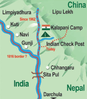 |
| nepal india disputed area |
In the above image the kali river is appears to unite from two source the smooth line which is boarder in 1816 because this is main kali river source and the dotted once is the present boundary. The british company after some years realised the important of that terain land and after a decade of treaty they asked the king of the nepal to change the boarder and take that part under their company. Later When india get freedom this part is added to india. In 2006 monarchy changes to democracy in nepal. The new government stated that the according to treaty of 1816 that three places are under nepal but india told that nepal's king agreed later when east india company asked for that place.so, that three places are under india. But we know that the nepalian and indian don't need a visa for coming india or nepal. People can independently where they want in disputed area. Then why this controversy started? This is because the road made in uttrakhand through lipulekh to china border for business purpose. But india did not informed nepal about the road construction. Otherwise in that region any construction started before informed both country. This is a problem and then protest started in nepal on 15 march.
The nepal government released the new map of nepal on 20th may, 2020 in which they included the three spots of india. This lead to the controversy between india and nepal. may this controversy will stop soon.
 |
| lipulekh |


Comments
Post a Comment